
Click image for more information and pictures
tabas Earthquake
TERA Corporation 2150 Shattuck Avenue Berkeley, California 94704
| Abstract |
|---|
Three triaxial sets of accelerograms recorded in the near source region (within 50 km epicentral distance) of the September 16, 1978, Tabas earthquake (Ms 7.4 ‐7.7) are of great engineering importance. The distances of the recording sites from the nearest approach of the rupture surface are approximately 3, 17, and 28 km for Tabas, Dayhook and Boshrooyeh stations, respectively. The measured horizontal peak ground accelerations of 0.94 and 0.88 g at Tabas are higher than previously estimated. The peak vertical ground acceleration recorded at this station is 0.74 g. The normalized response spectra at these three stations are consistent with the Newmark‐Hall elastic design spectra, suggesting that the latter adequately represent the spectral amplification factors at frequencies above 1 Hz. The main shock accelerogram at Dayhook exhibits at least three distinct events as indication of a complex source behavior. The widened spacing of these events on the Dayhook records further confirms that the rupture front moved northwestward away from this station and towards Tabas. The measured S minus trigger times at Tabas, Dayhook and Boshrooyeh stations are in conflict with the teleseismically determined epicenter, requiring it to move approximately 30 km to the southwest to about 33° 17′N, 57° 09′ E.
http://www.earthquakespectra.org/doi/abs/10.1193/1.1585401
tabas Earthquake
My PhD was done atCambridge, under the supervision of James Jackson, entitled ‘Active faulting andtectonics of eastern Iran’.
Iran provides a relativelycompact example of a young continent-continent collision zone, in which theactive faults and earthquake distributions are for the most part restrictedwithin the political borders of the country. In addition, the arid desertclimate, with an almost complete lack of vegetation and human habitation acrossmuch of the country, aids the preservation in the landscape of very subtleindications of surface deformation due to active faulting. Interpreting thedevelopment of landscapes in actively deforming parts of Iran can providedetailed information on the ways in which faults grow, evolve and interact. However, relatively few studies have attempted to unravel the local and regionalscale tectonics of Iran.
//tabas Earthquake  Click on the image to see in actual size
I looked at the surfaceexpression of active faulting in eastern Iran, utilising recent advances insatellite imagery and interpretation software to examine the geomorphology ofthe active regions, seismological investigation of recent earthquakes toconstrain the distribution and nature of active faults, and field investigationin a number of key areas. Much of the discussion concerns the active faultsystems that surround the Dasht-e-Lut desert (Figure 1). However, I also assessthe active deformation in the central parts of Iran (the central Iranian plateauand Dasht-e-Kavir), which appears to be part of the same tectonic story, eventhough there is no record of earthquakes in these central parts ofIran.
 //Click on the image to see in actual size
tabas Earthquake
Although I provide severalresults that are important for an appreciation of Iranian tectonics, there arelikely to be similarities in the ways that continental fault zones developirrespective of geographical location. Therefore, determining how faults aremanifest at the Earth’s surface in Iran, and using the surface expression offaulting to infer details about the growth and evolution of the faults, willprovide results that can be applied to other regions of active continentaldeformation, where the geomorphology might not be preserved to the samelevel.
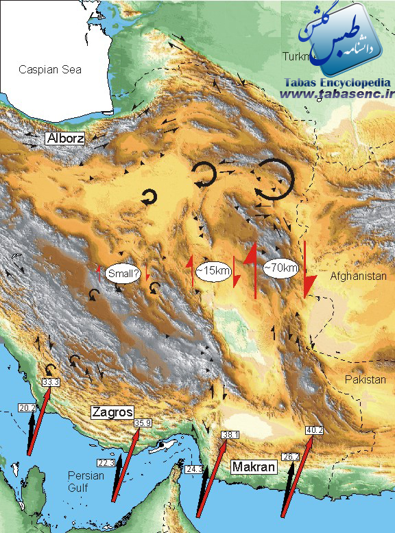
The active deformation ofIran is controlled by Arabian-Eurasian convergence. Shortening is mainlyaccommodated by distributed faulting in high mountains of the Zagros (Z) in thesouth, and the Alborz (A) and Kopeh Dagh (K) in the north. The surroundingregions to the north and east are aseismic and appear not to be deforming (Figure 1).
(a) Seismicity of Iran 1964-1998 (from the catalogue of Engdahl etal, 1998). (b) Avelocity field for Iran estimated from variation in strain rates indicated byearthquakes (Jackson etal, 1995).
Arabia-Eurasia convergenceis about 26 to 30 mm/yr at the longitude of eastern Iran. It seems likely thatabout half of this is taken up in the Zagros, leaving about 15 mm/yr to beaccommodated in the Alborz and central Iran. This must cause the same amount ofright-lateral shear in eastern Iran. There are several indications that thepresent-day tectonic configuration dates from around 5 million years ago. Wetherefore have some idea of how much deformation must be accounted for on theactive faults.
Eastern Iran is a regionof widespread active faulting (Figure 2). Right-lateral shear is taken up onseveral north-south right-lateral fault systems that surround the Lut desert (another aseismic block that is probably not deforming). In the north, theright-lateral shear is seen as clockwise rotation about vertical axes ofeast-west left-lateral faults (the Doruneh and Dasht-e-Bayaz faults). Shorteningcomponents associated with the strike-slip faults result in widespread thrustfaulting. These thrust faults often fail to reach the surface (termed ‘blind’ faults).
Fault map ofeastern Iran.
Many of these faultsystems have been responsible for destructive earthquakes, and pose a seriousseismic hazard to local populations. However, little is known of theirevolution, development and rate of slip. I hope to contribute to anunderstanding of the deformation in eastern Iran by investigating the long-termdevelopment and total Late Tertiary offset on the faults. By investigatingregions that have had destructive earthquakes, I can combine geomorphological, geological and seismological data to gain a better understanding of the ways inwhich strike-slip and thrust faults evolve. This also has importance for otherregions of active continental shortening.
Abstracts and images frompublished parts of my thesis are shown below. A more complete list ofpublications and conference abstracts can be reached through the links at thebottom of the page. If you would like any further information please don’thesitate to email me at the address given below.

- Offset and evolution of the Gowkstrike-slip fault, eastern Iran (a paper published in the Journal
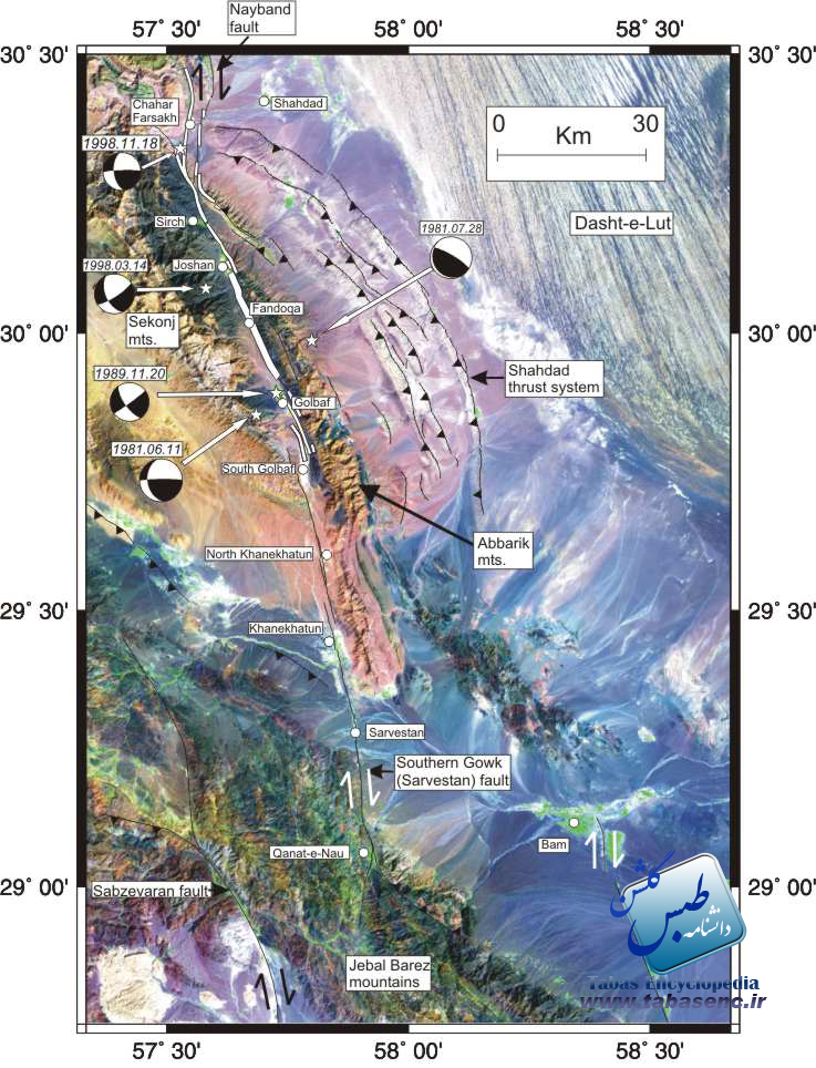
- of StructuralGeology Download PDF file)We usedrainage reconstructions to estimate long-term offsets on the Gowk fault, anoblique right-lateral strike-slip fault in eastern Iran, on which there havebeen a number of recent large earthquakes. A 3~km horizontal offset is inferredfrom well-preserved geomorphology. We further identify a total cumulative offsetof ~12~km, which produces a simple reconstruction of geomorphology across thefault, filling in pull-apart basins, restoring rivers to linear courses acrossthe fault trace and aligning structural and bed-rock features. The probable ageof the Gowk fault, and K-Ar dating of offset basalts north of the study region, suggest an overall slip rate of ~1.5-2.4 mm/yr. This is small compared to theoverall 10-20 mm/yr of shear expected between central Iran and Afghanistan andthe deficit is likely to have been accommodated on other faults east of the Gowkfault. Drainage displaced by dextral movement leads to the development of aseries of basins along the fault and a longitudinal topographic profile thatresembles an asymmetric saw-tooth. The geomorphic evolution of the fault zone atthe surface includes both normal and reverse faulting components, reflecting aprobable ramp-and-flat structure in cross-section. This interpretation isconsistent with evidence from the analysis of seismological, radar and surfacerupture data in recent earthquakes.
Landsat imageof the Gowk region. The parts of the fault that have ruptured the surface inrecent earthquakes are marked with a white line. The thickened line representsthe section that ruptured in 1981, and then again in 1998. Focal mechanisms ofthe five major earthquakes are included.
// Click on the image to see in actual size
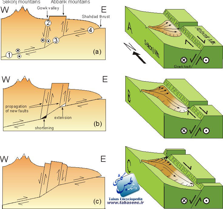
Left-handpanels: East-west cross-sectional views of the Gowk fault. The earthquakes andgeomorphology indicate a rather complicated fault zone, with a ‘ramp–and-flat’ structure on an oblique thrust fault causing uplift of mountains to the east ofthe Gowk fault valley. The 1981 earthquakes ruptured deeper parts of thestructure (1), and the 1998 Fandoqa earthquake ruptured the upper parts (2) witha slight normal component of motion. This structure is unstable and must evolvewith time. Right-hand panels: The influence of structure on landscapedevelopment within the Gowk fault valley. Vertical fault movements restrictrivers to a few deeply incised canyons. Lateral movements lengthen riverchannels and result in a distinctive ‘saw-tooth’ topography along the valley. Continued lateral movement may result in capture of the river by closeroutlets.
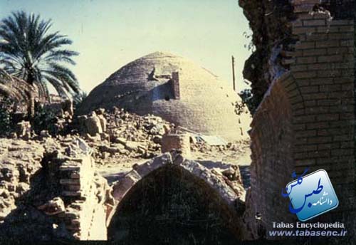
- Thrust faulting in eastern Iran (apaper published in Geophysical Journal International Download PDF file)Previouslyunrecognised thrust faults in eastern Iran were responsible for a destructiveearthquake at Tabas (16 September 1978), which produced over 80 km ofdistributed and discontinuous surface ruptures above a series of low anticlinalhills to the west of a major range-front. Analysis of long-period body-waveseismograms shows a simple rupture on a gently dipping (~16 degrees) thrust, with a slight right-lateral component. This is compatible with the locallyrecorded aftershock distribution. Body wave analysis of two later, smallerevents show similar source orientations. Several indicators of long-term activefolding at Tabas can be recognised in the geomorphology, and surface rupturesfrom 1978 are consistent with co-seismic fold growth. Drainage incision alsoindicates uplift at depth on thrust faults dipping eastwards beneath the folds. Body-wave seismograms for two earthquakes near Ferdows, 150 km east of Tabas, inSeptember 1968 also show thrust faulting at depths of ~10 km. Again, the surfacegeomorphology indicates a region of folding above a thrust fault, which is ~10km west of a fault bounded range-front. In both Tabas and Ferdows, the activefaulting appears to show Quaternary migration away from the range-front, possibly in response to stresses produced by the elevated topography. Theidentification of zones of active thrust faulting is important for earthquakehazard assessment and also for an understanding of the local tectonics. Weconclude that the structures which gave rise to the 1968 and 1978 earthquakescould have been recognised beforehand from the clear signals in thegeomorphology, had we known what to look for at that time.
tabas Earthquake
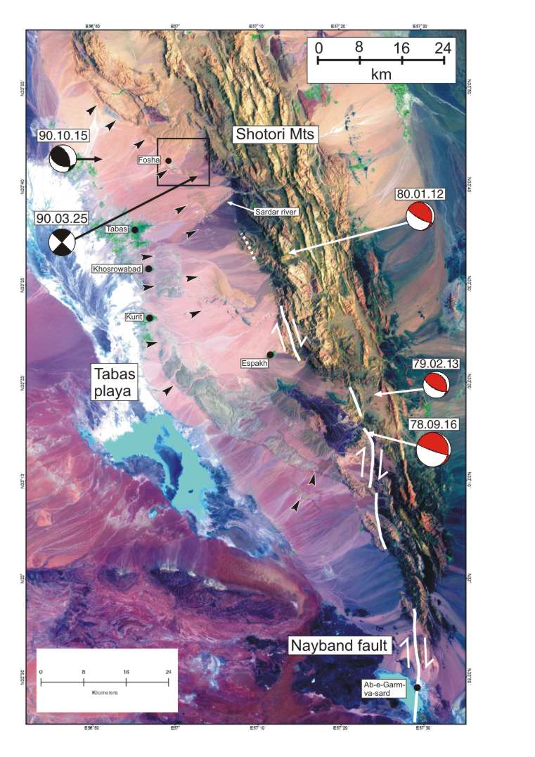
Landsat imageof the Tabas region with focal mechanisms of major earthquakes including the M 7.4 Tabas event (the most southern earthquake). The western margin of anticlinalfolds in Quaternary alluvium are marked with black arrows. These folds alignwith surface ruptures mapped after the 1978 event (Berberian, 1979)
/ /Click on the image to see in actual size
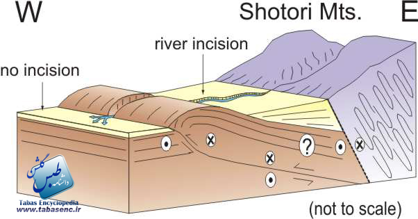
Schematiccross-section through the Tabas thrust fault. The main thrust fault at depth ispartially blind, and deformation at the Earth’s surface is mainly the result ofanticlinal folding. We can however infer faulting at depth from the patterns ofstream incision, as uplift of the hanging-wall of the thrust fault results inwidespread incision in the areas to the east of the surfacefolding
tabas Earthquake
Click on the image to see in actual size/ /
/
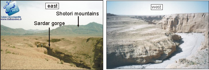
Fieldphotographs of river incision in the Sardar canyon near Tabas. The incisionresults from hanging-wall uplift on a thrust fault at depth, and stops at thewestern margin of the folds
- Active faulting and seismicity of theDasht-e-Bayaz fault, eastern Iran (a paper published in Geophysical JournalInternational Download PDF file) )TheDasht-e-Bayaz left-lateral strike-slip fault system in NE Iran ruptured over alength of ~120 km during two earthquakes in 1968 and 1979. We constrain thesource parameters of the 1968 August 31 (Dasht-e-Bayaz) and 1979 November 27 (Khuli-Buniabad) earthquakes by analysing long-period body wave seismograms. Both earthquakes involved complex rupture processes, with at least two subeventsin each case. Coseismic surface ruptures and cumulative scarps in alluviumindicate fault segmentation on numerous short (~20 km long) strands with smallpull-aparts between them. The earthquake subevents seen in the seismogramsprobably relate to this segmentation. The total, cumulative, offset on the faultsystem is estimated at ~4-5 km. This is small compared to the total amount ofLate Tertiary deformation expected in this part of Iran, and indicates that theDasht-e-Bayaz fault may be relatively young. Distributed strike-slip faulting iswidespread in the region and there are indications that the Dasht-e-Bayaz faultis evolving from several short faults that are coalescing. These results areimportant not only for understanding the regional tectonics but for thedevelopment and evolution of strike-slip faults in general.
- //
 Click on the image to see in actual size
 Click on the image to see in actual size
 tabas Earthquake
Landsat imagery of the Dasht-e-Bayaz region, showing mapped faults and mechanisms of major earthquakes.
/ Click on the image to see in actual size
The Dasht-e-Bayaz fault mapped from rupturesobserved after the 1968 and 1979 earthquakes (Ambraseys and Tchalenko, 1969: Tchalenko and Berberian, 1975). Although the fault appears to be moving rapidly, and shows evidence for several earthquakes during human history, the totaloffset of bedrock and geomorphological features is relatively small and thefault appears to be very young. We may be seeing the initiation of a newthrough-going fault from short segments that arecoalescing.
- Active tectonics and late Cenozoicstrain distribution in central and eastern Iran (in press, Tectonics) Right-lateral shear between central Iran and Afghanistan is accommodatedon N-S right-lateral strike-slip faults surrounding the aseismic Dasht-e-Lut. North of ~34 degrees N, the right-lateral shear is accommodated on left-lateralfaults that rotate clockwise about vertical axes. Little is known of the lateTertiary and younger offsets and slip-rates on the active fault systems, resultsthat are important for understanding the regional tectonics. We use observationsfrom satellite imagery to identify displaced geological and geomorphologicalmarkers, that we use in conjunction with the overall morphology and orientationof the active fault systems, to estimate the total cumulative right-lateralshear. Estimates of cumulative fault movements fromoffset features and inferredvertical axis rotation of fault-bounded blocks, suggest that the late Cenozoicstrain is concentrated towards the eastern margin of Iran, along the SistanShear Zone, where bed-rock offsets of at least 70 km are observed across theactive faults. The geomorphology of the Deh Shir, Anar and Great Kavirstrike-slip faults in central Iran suggest that although little shortening isaccommodated across this region, they might still be active, and hence capableof producing earthquakes. Present-day activity on these faults in central Iranwould not be expected from distributions of instrumental and historicalearthquakes. Although speculative, the late Tertiary strain distributiondescribed in this paper is consistent with what we know of the present-day ratesof shear in eastern Iran and provides a framework to which later, more detailed, work can be added
- Click on the image to see in actual size
 tabas Earthquake
Summary of the model of long-term deformation ineastern Iran. The largest amounts of late Cenozoic shear are found on faults inSistan province, in the far east of the country. This may mean that thepresent-day rates of slip are highest in Sistan. An uneven distribution ofright-lateral shear across eastern Iran may explain the initiation of the E-WDasht-e-Bayaz fault and the bending along the Doruneh fault to the north – asmore clockwise rotation of these E-W faults would be expected in the fareast.
- //

- Click on the image to see in actual size

http://www.gps.caltech.edu/uploads/File/People/kanamori/HKbssa81.pdf
Click image to view the pictures

کلیه حقوق برای سایت ” دانشنامه طبس گلشن ” محفوظ است
استفاده از مطالب و تصاویر با ذکر منبع ” دانشنامه طبس گلشن ” مجاز است
پاسخ دهید