

- A view on the geotourism attractions of the Tabas area-east of Iran
Mohammad Nazemi1, Shahla Maghzi najafabadi2
1- Faculty member of Islamic Azad University-Tabas branch. PH.D student at IAU- Sciences and Research branch,
Tehran, E-mail: nazemigeo@gmail.com
2 -Teacher of Tabas high schools and Payame Noor University -Tabas center
Abstract
Regarding its special geographical and ecological setting and its complex geological history, Iran, this vast land, is one of the few countries in the world that encompassing collections of various kinds of rare geological phenomena has attracted the interest and attention of many of the geologists from all over the world. Tabas, a small confined area in the eastern Iran, is one of the most important and attractive areas in which a wide spectrum of natural and geological attractions can be studied on a short and concise plan. The variation of geographical conditions and the existence of wide and thick outcrops that belong to different geological periods (especially Paleozoic and Mesozoic deposits) in relatively short distances in this area along with its poor plant cover has composed a matchless collection that amazes many of the geologists and researchers. For this reason, they name this area geological heaven and fossil museum of Iran. On the other hand, the complex history of the structural evolution of the area related to major and important faults of eastern Iran (Kalmard and Nayband faults) and seismic activities has made many interesting landforms and geological structures in result of the encountering internal and external dynamic processes. The Existence of important economic deposits like huge coal deposits has changed this area to a significant mining pole of eastern Iran. Some various categories of the most important geotourism attractions of the area have been introduced here. Finally it is suggested that this area can be introduced and recorded as geoparks to be used by inner or foreign ecotourists, geotourists, and all those interested.
Keywords: geotourism; geopark; Tabas; Iran
Introduction
The tourism industry, which is one of the most successful industries in the world, has recently paid a special attention to Ecotourism. Geotourism, an adventurous category of Ecotourism, not only attracts many Geologists but all those who are interested in nature and Earth. Iran, due to its specific geographical location, geological conditions, and rich cultural and historical background has an exceptional chance in the world of geotourism. Tabas, a small and restricted area in this vast country, is undoubtedly one of the best choices a geotourist can make in order to study various natural and geological phenomena in a short and intensive program. The variety of climatic conditions in such an arid area makes a special ecosystem with rare plant and animal species thereby composes a green gem on the vast and dry desert of Eastern Iran. On the other hand, the complexity and diversity of geological conditions and tectonics evolution during different geological periods since about 1 billion years ago has collected various geological phenomena in a small area and thereby provided the world geologists with the geological heaven and fossil museum of Iran.
 A view on the geotourism attractions of the Tabas
Geographical setting
Tabas is located in NE of Yazd province in latitude 3335′ N, longitude 5655 E. Its name, Tabas – meaning heat and temperature- roots in hot climate. They call it “Tabas-E Golshan” for its permanent vegetation as well as the existence of a garden called “Golshan. ” This garden with its famous pelicans that is one of the most beautiful gardens in Iran, along with “Hossein Ibn Musa holy shrine” are known as symbols of Tabas town. Adjacency with Lut Desert and Dasht-E Kavir desert (fig.1a) has caused a hot arid climate in this region so that temperature in Tabas town reaches over 50c at its highest rate. However, the existence of Shotori Mountain, which is about 2900 meter high, has formed plenty water reserves, permanent rivers, and green valley’s in this area, which have many ecotourism attractions. Scattered and small human residences in this vast arid area provide good conditions for the Naybandan wildlife shelter with about 1500000 hectares that holds the last remnants of Asiatic cheetah.
Natural and tourism attractions
Apart from the geological features, having rich historical background and being located near Silk Road and trade – Pilgrimage routes in the past have resulted in different historical and cultural works and symbols. A majority of these constructions have been destroyed because of wind, rain, and earthquakes. To name some of these works, caravanserai that have been built for the accommodations of the caravans in the desert such as Caravansary of Jovkhah, Robat Gore, Robat Khan, Robat Kalmard, and castles such as Tabas government Citadel , Nayband, Kharv, Gholat, Khravan, and Mok-E Shor,and Malvand can be mentioned. In addition, the beautiful desert landscape is another natural attraction of the area.
Geological setting
This region is located in Central Iran, which is a set of suspect terrains that have connected together during different geological periods. This terrain is separated from the Lut block by Nayband fault and Shotori Mountains and from western block by Kalmard-Kalshane bent faults. This block is also segmented into smaller zones by large and deep faults. Process of geological evolution of the Tabas block in Paleozoic age does not conform to the adjacent areas. As an example, lack of clear Eifelian hiatus evidences and existence of Upper Carboniferous deposits (Sardar formation) that is rare in other parts of Central Iran can be mentioned. Occurrence of severe Subsidence in overall of the Tabas block during Paleozoic and Mesozoic Era caused one of the perfect and thickest stratigraphic columns of Iran with a thickness of 17000m [6, 1]. According to geological and structural characteristics, Tabas block can be divided into zones such as: Shotori fold and trust belt, Tabas contractional depression, Ravar – Mazino zone, Parvadeh – Nayband zone and Kalmard zone.
Geomorphologic landscape and phenomena
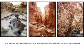
Geomorphologic landforms and perspectives make the main Geotourism attractions in any area. Due to warm and dry climate and geological characteristics, a wide range of landscape types including Canyon (fig.1b, c) (in Shotori mountain), Meander (Sardar river), varied erosion shapes & stream capture (fig.3a, fig.6b, c) (Kaal-E Jeni rive), cuesta (Parvadeh areas), Playa (center of Tabas plain), Nebka (around the village Jovkhah), varied sand dune, hot water mineral springs and etc. have been formed in Tabas. Many of these phenomena can be observed in relatively short Geotourism path like, Kaal-E Sardar river(fig.1a,b ,fig.3b) and Tang-E Abbasi narrow glen and Kaal-E Jenni river(fig.6b,c) and Azmayghan village (north of Tabas) that can be introduced as Geoparks.[5]
Stratigraphy and fossils attractions
The poor vegetation conditions facilitate the study of several outcrops of different geological period’s deposits. Thus, many of Paleozoic and Mesozoic deposits have been studied for the first time in this area and introduced to the geology of Iran as its type section. Altogether, more than 20 type sections of geological formation have been studied in an area of less than 300 kilometers long. These sections are mainly located in the Dranjal-Ozbakuh Mountains (North), Kalmard Mountain (West), Shotori Mountain (East), and Nayband-Parvadeh area (south).The existence of many types of marine fauna fossils in these deposits has caused Tabas region to become an important storage of Iran fossils.
Economic geology and mining attractions
Because of the existence of various kinds of rocks, tectonics setting, and magmatism events in this area, more than 200 types of minerals have been discovered of which many are being extracted in mines in operation. The most important of these would be the following minerals: Coal, casting sand (thick quartz arenite in base of Jamal formation that is being extracted in Chirok open pit mine), and Fluorine (with more than 90 percent purity that is being extracted in Kamar-E mehdy mine). About 1 billion tons of the mentioned coal was deposited in Upper Triassic – Jurassic age that is the biggest coal store in Iran. These Coals are of two kinds: coke and anthracite, which are respectively extracted in full-mechanized Parvadeh mines and Mazinu mines. (fig.3b) Building stones, gypsum, barite, refractory soil, stones, Bentonite, sodium sulfate, Agate, lead and zinc, copper, feldspar, manganese, iron, and Celestine are some other samples.
Structural geology and tectonics attractions
Nayband and Kalmard faults, two major faults of Iran with their names respectively derived from Nayband beautiful village in the south of Tabas, and Kalmard Caravansary in West of Tabas, have formed particular tectonics settings and structures. The existence of these two faults provides ideal conditions for studying geological structures and their impact on human societies. The high frequency of morphotectonics evidences and seismicity (e.g. 1978 Tabas earthquake) indicates the high rate Tectonics activity in this area. Some instances of the beautiful folds and faults structures are shown in fig.4a, 4b, and 5a.
Ancient engineering constructions
The arid climate forced the first residents of this area to find ways to conserve valuable water resources. Thus, in addition of numerous Qanats, some very interesting examples of old dams are seen that were being used for storage and consumption of seasonal floods. One of these dams is Band-e-Korit (Called Band-e-Korit, since it has been built for the provision of water for Korit village located in 26km to the west of the Dam) which is an ancient arched Dam (fig.5b) that using a scientific manner was built in a perfect geological setting on the Korit- River. With 700 years of age and a height of more than 60m [2], Korit dam is one the oldest dams in the world and has been the tallest ancient building in the world for a long period. To mention another example, we can name the historic dam of Tagh-E Shah Abbas (fig.1c) that has been constructed on the Sardar River (Eastern Tabas). It is not clear why this dam has been left uncompleted. Of course, some believe that it was built to be used for adjusting the floods flowing in Sardar river to prevent Tabas town against being destructed. Also, “Khane- ye- Gabr,” the tunnels made in the vertical alluvium wall of Sardar river and Kaal-E Jenny valley is interesting in terms of architecture. It is believed that these tunnels with their side chambers have been ancient human habitats or Mithras follower’s temple (fig.6a).
 A view on the geotourism attractions of the Tabas
Acknowledgment
We would like to express the deepest appreciation to our friends Mr. Zarrabi, Mr. Najafi, Dr. Bani_Assadi, and Mr. Parvaneh, without whose guidance and persistent help this article would not have been possible. In addition, we thank Islamic Azad University- Tabas branch for providing for supporting this project.
Reference:
1- Aghanabati.S.A. (1383) geology of Iran, GSI. Pub.
2- Daneshdust, Y., 1997, Tabas, the town that has been. Vol 2, historical building of Tabas.
3- Nazemi, M., 1998, Neotectonics of the Tabas block with a view on the Quri Chay structural geology (Parvadeh coal bearing area-south Tabas), M.S. thesis in G.S.I., Tehran, Iran.
4- Nazemi, M. & Maghzi, Sh.,2007, Neotectonics investigations in Kaal-E Jeni path, north of Tabas., 3th congress of mine and related scinces, I.A.U. -Tbas branch.
5- Nazemi, M., 2009, Intruduse and investigate of geotourism and mining attraction of the Tabas area, reaserch project,I.A.U.i Tbas branch.
6- Stocklin, j, et al. (1965).Geology of the Shotori Range (Tabas area, East Iran) Geol . sur. Iran, Rep. No 3, P.69.
7- Ruttner,A., M.H.Nabavi and Hajian (1968) Geology of the Shirgesht area (Tabas area east iran) G.S.I 733 pp.
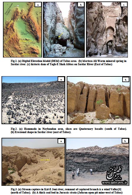
Fig.1. (a) Digital Elevation Model (DEM) of Tabas area. (b) Morteza Ali Warm mineral spring in Sardar river. (c) historic dam of Tagh-E Shah Abbas on Sardar River (East of Tabas)
Fig.2. (a) Hammada in Naybandan area, slices are Quaternary basalts (south of Tabas). (b) Erosional shape in Sardar river (east of Tabas).
Fig.3. (a) Stream capture in Kal-E Jeni river, remnant of captured branch is a wind Valley[5] (north of Tabas). (b) A thick coal bed in Jurassic strata (Jafaran open pit mine-west of Tabas)
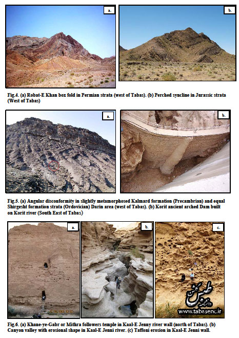
Fig.4. (a) Robat-E Khan box fold in Permian strata (west of Tabas). (b) Perched syncline in Jurassic trata (West of Tabas)
Fig.5. (a) Angular disconformity in slightly metamorphosed Kalmard formation (Precambrian) and qual Shirgesht formation strata (Ordovician) Darin area (west of Tabas). (b) Korit ancient arched Dam built on Korit river (South East of Tabas)
Fig.6. (a) Khane-ye-Gabr or Mithra followers temple in Kaal-E Jenny river wall (north of Tabas). (b) Canyon valley with erosional shape in Kaal-E Jenni river. (c) Taffoni erosion in Kaal-E Jenni wall.
صفحه اصلی
Home
“The use of content with attribution (www.tabasenc.ir) is permitted.”
کلیه حقوق برای سایت ” دانشنامه طبس گلشن ” محفوظ است
استفاده از مطالب و تصاویر با ذکر منبع ” دانشنامه طبس گلشن ” مجاز است
پاسخ دهید